Stormwater Projects

Stormwater Services implements projects that improve the stormwater drainage system and benefit our environment. Projects consist of capital improvement projects, in-house projects, and green/grant projects.

Public Comment Form - give input on projects, the City's Stormwater Program, etc.(PDF, 153KB) 

Current Stormwater Capital Improvement Projects (CIP)

Stormwater capital projects are constructed when the existing stormwater drainage system is inadequate and results in flooded streets and property. Stormwater capital projects also strive to improve water quality whenever possible. Stormwater utility fees provide the funding and staff resources for planning, design and construction of capital improvement projects.

Stormwater capital projects are time intensive and involve several major stages from start to finish:

  1. Planning / Future Projects
  2. Design / Permitting
  3. Under Construction
  4. Completed

* Projects are listed in alphabetical order, not by project status.

Brookshire / Beasley

Brookshire/Beasley Drainage Improvements Map(PDF, 2MB)

The Brookshire Ln/Beasley Rd Stormwater Improvements project is a large drainage improvements project in the Pine Valley East residential area. The project area drains to a tributary of Hewletts Creek and drains the land areas generally including Brookshire Lane, Waltmoor Road, Aster Court, and Whisper Creek Lane. The project is required to reduce the flooding of streets and private property in the area. The existing drainage infrastructure has aged and requires upgrading.

The project required the city to establish permanent drainage easements along the drainage way for construction and for long-term maintenance by the city. The easement acquisition phase began in summer 2020 and was completed in Spring 2023. Currently, the construction plans and all permits are being finalized. After all construction plans and permits have been finalized, the city will advertise the project for construction bids. The bids will be based on the plans that have been completed by a consulting engineering firm hired by the city. Once the city selects a general contractor, a schedule for construction will be established.

Project History

Brookshire/Beasley Project Scope Map(PDF, 344KB)

Beasley Road Bridge Replacement

In August 2017, crews completed replacement of a bridge on Beasley Road as part of the $4 million drainage improvement project in the Brookshire Ln/Beasley Rd area.

Public Input

The city held two public meetings, May 30, 2013 and March 11, 2014 to get public input from residents in the Brookshire-Beasley area on the planned stormwater drainage improvement project. This $4 million project will be one of the largest draining/flooding improvement projects the city has ever done.

Some of the drainage improvements related to this project were already been completed as part of the construction of the Gary Shell Cross-City Trail in the area. The project was extended to include the installation of a new, large drainage pipe under Waltmoor Road. Combining the construction of the trail with the additional drainage improvements allowed the city to complete the work with the least amount of disruption to citizens. A new culvert was also installed under Brookshire Lane in late 2015 as part of this project.

Please visit the links below to review items that have been discussed and presented at past public input meetings.

Project History

Clear Run Branch

Clear Run Branch Landscape Map(PDF, 1MB)

The map above illustrates Phase 1 and 2 of the Clear Run Branch drainage improvement project(PDF, 629KB).

This $11 million project is the largest stormwater capital improvement project that the City of Wilmington has undertaken to reduce chronic flooding, improve water quality, and enhance natural habitat. Clear Run Branch is highly impacted and impaired due to excessive stormwater flows from upstream development.

Phase 1: Install large box culverts (pipes) to convey stormwater under College Acres Drive and Mallard St. This phase also includes major stream restoration and floodplain creation to increase flood storage capacity and improve the natural characteristics of Clear Run Branch stream.

Final easement acquisitions are complete. The lowest responsive and responsible general contractor (East Coast Contracting, Inc.) bid was approved by City Council on April 19th, 2022. Construction is likely to begin in May 2022. It will be a 12 month construction schedule. Postcard notices(PDF, 2MB) were mailed to all local residents about the project, contact information and new traffic patterns/detours. We ask for patience and understanding with the traffic pattern changes and with the general construction activity to make these necessary drainage improvements.

Phase 2: Install large culverts to capture and convey floodwaters from the S. College Road/New Centre Drive commercial areas and tie into the drainage improvements installed during Phase 1. This phase includes incorporating as much green infrastructure as possible help filter out pollutants and reduce the amount of runoff flowing from impervious surfaces into Clear Run Branch, then ultimately Bradley Creek.

Greenville / White Avenue

Greenville Ave./White Ave. Drainage Improvements Map(PDF, 1MB)

The Greenville Ave./White Ave. Drainage Improvements are a 2-phase project.

Phase 2 will include additional storm drainage pipe design along White Ave. to an area where an open channel will be improved. This phase will connect directly to the uppermost end of Phase 1. Phase 2 design work is anticipated to begin in winter 2023.

Phase 1 of the project is complete. It is located primarily within the Wrightsville Green residential neighborhood and was designed to reduce street and private property flooding in that neighborhood exclusively. The project included new storm drainage pipes and ditches that are sized to carry stormwater runoff from the sub-watershed. The sub-watershed begins near the Oleander Drive and Hinton Road intersection. This phase included new permanent drainage easements that were acquired by the city from individual property owners. These easements were required to construct the project and to allow for future access by city maintenance crews.

Kelly Road

Kelly Road Capital Improvements Drainage Project Map(PDF, 1MB)

Kelly Road Capital Improvements Drainage Project is a project generally including Beasley Road, Kelly Road, Sandhills Drive and Chelon Avenue. The area consists of drainage infrastructure that is antiquated and undersized. The major stormwater outfall flows behind the new residential development, The Homeplace, on Casa Court. This outfall was recently cleared of felled trees and debris by the City and flows to the drainageway where the new Beasley Road bridge is located. This project is located within the Hewletts Creek Watershed.

The project is required to improve existing drainage infrastructure such as culverts, inlets and open channels. The project study will include land survey, modeling and developing engineered design alternatives to reduce flooding of these local streets and private property. Additional infrastructure may also be required. The project may require additional easement acquisitions to establish permanent drainage easements along the drainageways for construction and for long-term maintenance by the city.

The Kelly Road CIP will begin with survey in approximately Fall 2022. Notification letters will be mailed to all residents both for the survey, where property access is required, and secondly to all residents to provide the drop-in community meeting information. This community meeting will be an open drop-in meeting at a public facility as close to the neighborhood as possible.

Pirate Cove

The Pirate Cove neighborhood and Masonboro Sound Rd. area experience flooding during certain storm events. The city hired a consulting engineering firm to study the existing drainage system and determine what flood reduction improvements could be made to the maximum extent feasible. The Pirate Cove Drainage Improvements project generally consists of improvements to the existing drainage system within a portion of the Pirate Cove subdivision to reduce flooding.

The project required the city to acquire easements for construction and for long-term maintenance. The easement acquisition phase is currently underway; also, construction plans and permits are being finalized. After all construction plans and permits have been finalized, and all easements are acquired, the city will advertise the project for construction bids. The bids will be based on the plans that have been completed by the consulting engineering firm hired by the city. Once the city selects a general contractor, a schedule for construction will be established.


Project Plans for the Pirate Cove Project Map(PDF, 2MB)

Drainage Improvement Map for the Pirate Cove Project(PDF, 1MB)

Red Berry Dr.

Red Berry Drive Drainage Improvements Map(PDF, 1MB)

Project Update 5-19-23(PDF, 1MB)

Red Berry Drive Stormwater Drainage Improvements Summary(PDF, 1MB)

Red Berry Drive and adjacent properties experience flooding during storm events. The City has hired an engineering consulting firm to assist with studying the existing drainage system and determine what improvements can be made. The study began in Winter 2020 and improvement alternatives were identified through the study’s engineering analysis and a preferred alternative was selected for community review.

Stormwater Services held a community drop-in meeting with neighborhood residents on January 20, 2022. We received a lot of positive feedback from the residents in attendance, and we are now moving forward with the Engineering & Design Phase. We aim to have the project go to bid in Winter 2024 and begin construction in Summer 2024.

Whispering Pines

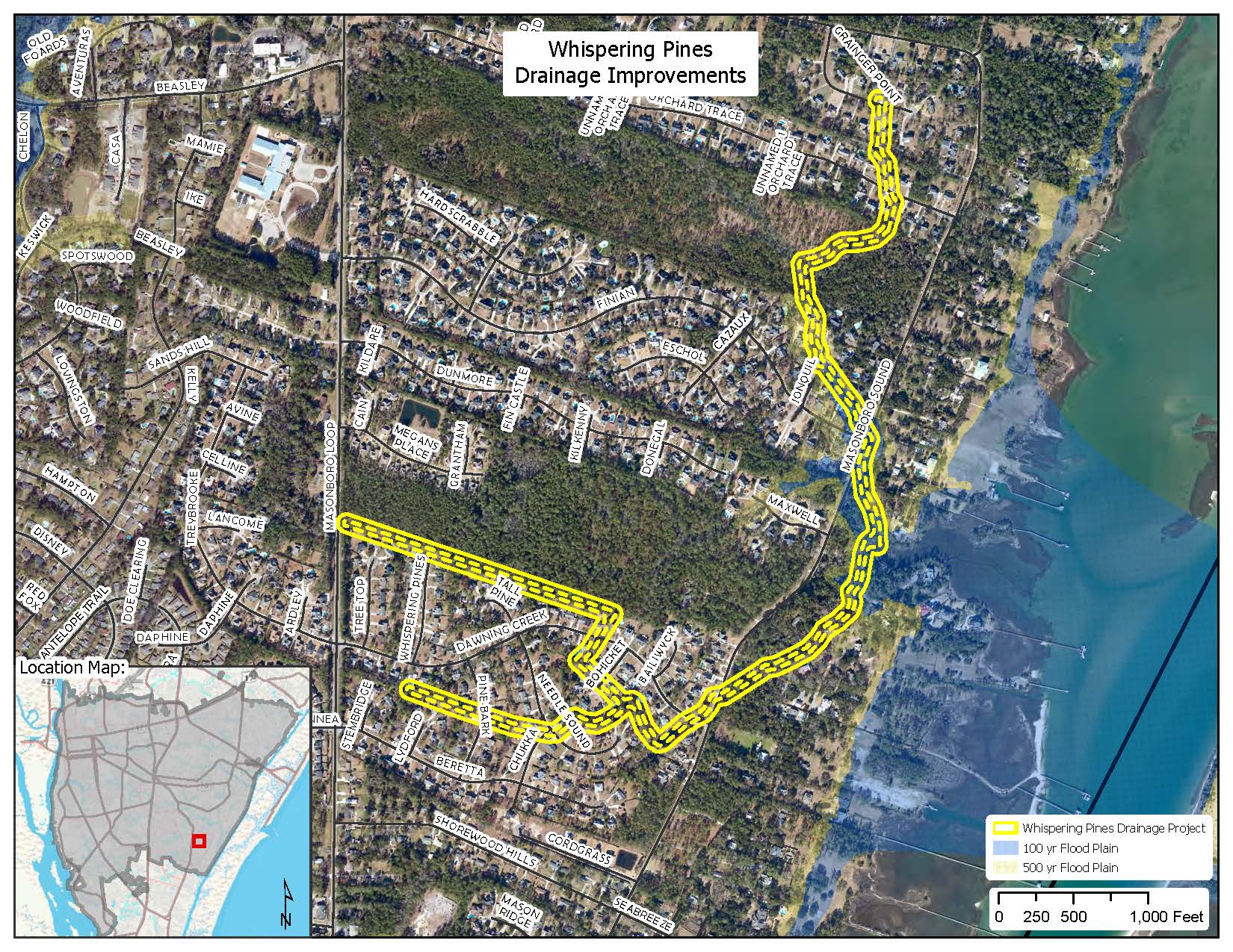
Whispering Pines Drainage Improvements Map(PDF, 1MB)

Meeting Letter for Residents(PDF, 195KB)

Areas of Concern Map(PDF, 145KB)

Project Area Alternatives(PDF, 3MB)

Whispering Pines Capital Improvements Drainage Project is a large-scale project generally bounded by Masonboro Loop Road to the west, Orchard Trace to the north, Masonboro Sound Road to the east, and Shorewood Hills Drive to the south. The area consists of multiple drainage areas (sub-watersheds) that drain up to four distinct neighborhoods. These multiple sub-watersheds and outfalls all flow directly into the Intracoastal Waterway to the east.

The project will improve existing drainage infrastructure such as culverts, curb inlets and open channels. The project study will include land survey, modeling and developing engineered design alternatives to reduce flooding of these local streets and private property throughout this area. The existing drainage infrastructure has aged for many years and requires up-grading. Additional infrastructure may also be required.

Preliminary Engineering is completed. A Meeting Letter for Residents(PDF, 195KB) has been mailed out to residents for a drop-in community meeting on October 11th at Fire Station #15 (3335 Masonboro Loop Rd, Wilmington, NC 28409) to hear from interested residents about their specific drainage issues and to provide comments concerning the proposed drainage improvement alternatives.

This project requires easement acquisitions to establish permanent drainage easements along the drainageways for construction and for long-term maintenance by the city. These easement locations will be available for viewing and discussion at the community meeting.

Wisteria / Clearbrook Dr.

Wisteria / Clearbrook Capital Improvements Drainage Project Map(PDF, 1MB)

The Wisteria/Clearbrook Drainage Improvements – Stage II project is a large drainage improvements project generally beginning in the Camellia Heights residential area and ending at Dogwood Lane, south of Oleander Drive. This area drains to a tributary of Hewletts Creek and drains the land areas generally including 58th Street, Wisteria Lane, Ruxton Way, Weeping Willow Road, and Dogwood Lane. The project is required to reduce the flooding of streets and private property. The existing drainage infrastructure has aged and requires upgrading. This project requires easement acquisitions to establish permanent easements along the drainage-way for construction and for long-term maintenance by the city. The easement acquisition phase is currently underway.

After all required easements have been purchased and plans/permits are finalized, the city will advertise the project for construction bids. The bids will be based on the plans that have been completed by the consulting engineering firm hired by the city. Once the city selects a general contractor, a schedule for construction will be established.

Stage I of the Wisteria/Clearbrook Drainage Improvements project was completed in 2015/2016.


CIP Projects - Completed & In-Progress

Click on the Completed Capital Improvements Map to view stormwater capital improvement projects that are in-progress or have been completed.

Stormwater Projects Map(PDF, 2MB)


Current In-House Projects

In-House drainage projects consist of smaller to medium-size projects that are designed and permitted in-house and constructed by city in-house crews.

Barksdale Road

This project involves replacing the existing storm pipe crossing underneath Barksdale Rd, just south of the intersection of Barksdale Rd. and Kelly Rd. The existing pipe is metal and has started to deteriorate, causing cave-ins on the street.

It was also discovered that an existing water main was bored through the existing stormwater pipe. The City coordinated with CFPUA to relocate the existing water main in the winter of 2020.

The existing storm pipe can now be removed and replaced; construction is planned for Summer 2021.

Darby Street

Storm pipe installation is proposed in the vicinity of 137/141 Darby Street. Roadway flooding occurs at this location. A new storm drain and pipe are required to direct stormwater runoff from the road to the existing ditch behind the properties.

The City must acquire public drainage easements to complete this project. Design was started in the Fall of 2020 and easement acquisition is ongoing. Construction will begin once all necessary easements have been acquired.

Renee Court

This Project will address roadway flooding in the Renee Ct. cul-de-sac.

The Design plans are complete. Project is awaiting the public bid process.

Completed In-House Projects

The following in-house projects have been completed since 2020.

Buccaneer Road

This project consisted of replacing stormwater pipes in the vicinity of 410 and 414 Buccaneer Road.

The existing stormwater pipe at this location had collapsed in multiple spots and was causing the road to flood during rain events. The existing pipe was removed, and a new pipe was installed.

The area downstream of the pipe was regraded to allow the pipe to flow better. A back flow valve was also installed on the new pipe, to prevent high tide events from flooding the street.

Project design started in the Fall of 2019, and construction was completed in the Summer of 2020.

Shell Road Village

A cave-in on the road developed above an existing 30" metal storm drain

City staff abandoned the existing storm drain and installed a new one outside of the roadway area.

The project was designed and constructed in 2019.

Green & Grant Projects

Learn about our stewardship awards and numerous grant projects.